-40%
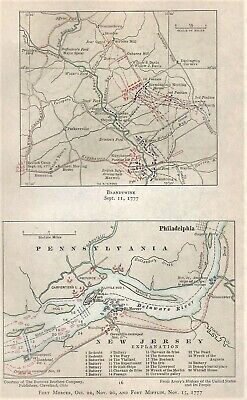
Antique 1777 Revolutionary War Maps BRANDYWINE & FORTS MERCER & MIFLIN
$ 6.83
- Description
- Size Guide
Description
This page shows 2 maps, one titled "BRANDYWINE Sept 11,1777"
, and the 2nd titled "
FORT MERCER, Oct. 22. Nov. 20, and FORT MIFLIN, Nov. 15, 1777
."
The page accompanied a publication titled "The Revolutionary War and the Military Policy of the United States" which was published in 1911.
Some names I see on maps include Philadelphia, Delaware River, Cornwallis Encampment, Nov. 21, Fort Billingsport, Carpenter's Island, Little Mud I., Province I., Hollander's Creek, Cooper's Ferry, Hog I., Red Bank I., Woodbury I., Gloucester, Kennett Meeting House, Parkersville, Darlington Corners, Brinton's Ford, Wistar's Ford, Wilmington Road, Strode's Mill, Osborne Hill, Pocopson, Sullivan, Buffington's Ford, Major Spear, Birmingham Meeting House, Knyphausen, and many more.
Page measures approx 5 1/2" by 8 5/8", pair of maps together approx 4 1/2" by 7" with blank back on lightweight paper. It is in excellent condition.
MAP IS MUCH SHARPER AND CLEARER IN REAL LIFE THAN IT IS IN MY BLURRY SCAN.
Satisfaction guaranteed, successful bidder to
prepay and include .50 for 1st class S & H in the US without a tracking number. Thank you.
Multiple similar items may be combined for a reduction in postage.
.
Track Page Views With
Auctiva's FREE Counter
